The 10 Most Dangerous Roads in India That Are Worth Driving Anyway
4x4 mandatory. Oxygen optional. Views non-negotiable.
Destinations in this article
NakshIQ rates every destination on a reach difficulty scale. We log road conditions, public transport availability, last-kilometer difficulty, and whether you need a 4x4 or just courage. Most destinations in India score "easy" or "moderate." These 10 scored "hard" or "extreme." They are also among the most rewarding drives on the planet.
1. Leh to Umlingla — 5,883 Metres Above Sea Level
The highest motorable road in the world. Not a marketing claim — a verified altitude. The road from Leh to Umlingla via Hanle covers 260 kilometres and takes 8 to 10 hours. Our reach data is blunt: 4x4 mandatory. BRO maintains the road but conditions vary between poor and fair. Much of it is unpaved. There is zero public transport. You must hire a vehicle from Leh.
The last-kilometer difficulty rating: extreme. Oxygen levels at 5,883 metres are roughly 50% of sea level. Your body will remind you of this repeatedly.
Why it is worth it: you are driving on the roof of the world. The Hanle Dark Sky Reserve sits at the end of this road. On a clear night, you see the Milky Way with a clarity that makes you question every planetarium you have ever visited.
4x4 mandatory. BRO maintains the road but conditions vary. There is zero public transport. You must hire a vehicle from Leh.
2. Chang La to Pangong Tso — 5,360-Metre Pass
Pangong Lake sits at 4,350 metres. To reach it, you cross Chang La at 5,360 metres. Our data: 4WD essential. Fuel up in Leh because there is nothing between. Road condition: rough with unpaved sections. Chang La itself is extreme.
The 150-kilometre drive from Leh takes 5 hours. Shared taxis exist but offer no comfort guarantees. The last-kilometer difficulty: extreme.
Why it is worth it: Pangong changes colour seven times in a single day. That is not poetry. It is optics — the lake is so large and shallow that light refracts differently as the sun moves. No photograph captures it accurately.
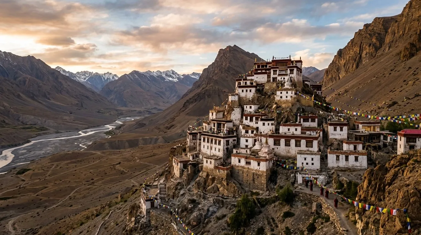
3. Kargil to Zanskar Valley via Pensi La
Zanskar is what Ladakh was 20 years ago. Getting there requires crossing Pensi La on a road that is only open July through September. Our reach data: 4WD mandatory. Road condition is rough and seasonal. Public transport is limited to rare shared taxis.
The 230-kilometre drive from Kargil is classified as extreme last-kilometer difficulty. Alternative access: the frozen Chadar River in winter. Or a 3-plus-day route from Manali.
Why it is worth it: genuine monasteries without tour buses. Communities that rarely see outsiders. The last frontier of Indian travel.
Worth every white-knuckle kilometre. But download offline maps, carry extra fuel, and acclimatize properly above 3,500m. Altitude sickness is not a badge of honour.
NakshIQ Safety Note
4. Manali to Spiti Valley — Rohtang and Kunzum
Two high passes. 200 kilometres. 8 to 10 hours. The Manali side is unpaved. The alternative Shimla route via Kinnaur is paved but landslide-prone. HRTC runs a seasonal bus that is not for the faint-hearted.
Our difficulty rating: hard. A 4WD is recommended, not optional, on the Manali approach. The Kunzum Pass section has no guardrails in several stretches.
Why it is worth it: Spiti Valley at 3,800 metres is a cold desert that looks like it belongs on Mars. Key Monastery perched on a cliff. Dhankar hanging over the confluence. October scores 5/5 on NakshIQ — the circuit closes mid-to-late month, so timing is everything.
5. Rishikesh to Kedarnath — Then You Walk
You can drive to Sonprayag. After that, no vehicles. The Char Dham highway handles cars, but monsoon landslides are routine. From Gaurikund, it is a 16-kilometre trek or a helicopter ride.
Our data: road condition subject to monsoon landslides. Last-kilometer difficulty: extreme, because that last kilometer is actually 16 kilometres on foot at 3,583 metres.
Why it is worth it: Kedarnath is one of the most significant Shiva temples in India. The 2013 floods reshaped the landscape but the temple stood. The trek itself passes through terrain that reminds you why these mountains are considered sacred.
6. Tezpur to Tawang — Sela Pass at 4,170 Metres
450 kilometres from Guwahati. 14 to 16 hours of driving. Sela Pass at 4,170 metres brings fog, ice, and single-lane BRO-maintained roads. AWD recommended. APST buses from Tezpur exist but are limited.
Our difficulty rating: hard. The Bomdila to Tawang section (180 kilometres, 7 hours) is the most demanding stretch, with landslide-prone single-lane roads and steep drops.
Why it is worth it: Tawang Monastery is the largest in India and second-largest in the world after Lhasa. The Arunachal Pradesh permit requirement keeps crowds low. At 3,048 metres, the town sits in a valley that catches golden light in ways that make photographers weep.
7. Leh to Tso Moriri — 220 Kilometres of Nothing
4x4 mandatory. Rough unpaved roads with stream crossings. BRO maintained but basic. No public transport — you must hire from Leh. Eight hours for 220 kilometres.
Our last-kilometer difficulty: hard. The lake sits at 4,522 metres in a valley so remote that your phone will show no signal for most of the drive.
Why it is worth it: everything Pangong promises without 500 tourists recreating the same photograph. Real nomadic camps. Rare black-necked cranes. Actual solitude. This is in our tourist trap alternatives database — Tso Moriri is what you thought Pangong would be.
8. Srinagar to Gurez Valley via Razdan Pass
Seasonal road open June to October. Razdan Pass at 3,300 metres is steep. 4WD recommended. Shared taxis are rare. 123 kilometres from Srinagar.
Our difficulty rating: hard. The road is narrow with sharp switchbacks and no barriers in several sections.
Why it is worth it: Gurez is a valley that most Indians do not know exists. The Kishanganga River runs through it. Habba Khatoon peak overlooks everything. Military presence is heavy but the locals are among the most welcoming in Kashmir.
9. Lohajung to Roopkund — The Mystery Lake Trek
You can drive to Lohajung in a high-clearance vehicle. The last 50 kilometres to the trek base are rough. Then it is an 8-day trek to 5,029 metres where a lake full of ancient human skeletons awaits.
Our reach data: road condition to Lohajung via Karnaprayag is rough mountain road. Then the trek is multi-day with extreme last-kilometer difficulty. Rishikesh to Lohajung is 260 kilometres and takes 10 hours.
Why it is worth it: Roopkund is one of the greatest unsolved archaeological mysteries in India. Hundreds of skeletal remains from the 9th century, possibly killed by a sudden hailstorm. The trek passes through Bugyal meadows that are among the most scenic in the Himalayas.
10. Jammu to Kishtwar — The Overlooked One
320 kilometres. 10 hours. Mountain roads from Jammu via Doda. Fair but narrow. Landslide-prone in monsoon. Buses run from Jammu but take 10 to 12 hours. No rail. Jammu airport is 320 kilometres away.
Our last-kilometer difficulty: moderate, which makes this the most accessible entry on this list. But the road itself is genuinely narrow in sections with sheer drops.
Why it is worth it: Kishtwar sits at 1,638 metres and is the gateway to some of the most challenging mountaineering in the Indian Himalayas. The town itself is a crossroads of Kashmiri, Dogri, and Ladakhi cultures. Almost nobody visits, which is precisely the point.
Before You Drive Any of These
Carry extra fuel. Inform someone of your route and expected arrival. Check BRO road status reports (bro.gov.in) before departure. Acclimatize properly for anything above 3,500 metres — altitude sickness is not a badge of honour, it is a medical emergency. And download offline maps. Your phone will lose signal on every single one of these routes.
Monthly Scores
| Destination | Jan | Feb | Mar | Apr | May | Jun | Jul | Aug | Sep | Oct | Nov | Dec |
|---|---|---|---|---|---|---|---|---|---|---|---|---|
| Gurez Valley | — | — | — | — | 4.0 | 10.0 | 10.0 | 8.0 | 10.0 | 6.0 | — | — |
| Kedarnath | — | — | — | 2.0 | 10.0 | 10.0 | 4.0 | 4.0 | 8.0 | 10.0 | 2.0 | — |
| Kishtwar | 2.0 | 2.0 | 4.0 | 4.0 | 6.0 | 10.0 | 8.0 | 8.0 | 10.0 | 6.0 | 2.0 | 2.0 |
| Pangong Tso | 2.0 | 2.0 | 2.0 | 2.0 | 4.0 | 10.0 | 10.0 | 8.0 | 10.0 | 4.0 | 2.0 | 2.0 |
| Roopkund | — | — | — | 2.0 | 8.0 | 10.0 | 4.0 | 2.0 | 6.0 | 8.0 | 2.0 | — |
| Spiti Valley | 2.0 | 2.0 | 2.0 | 4.0 | 8.0 | 10.0 | 8.0 | 8.0 | 10.0 | 10.0 | 4.0 | 2.0 |
| Tawang | 2.0 | 2.0 | 2.0 | 8.0 | 8.0 | 2.0 | 2.0 | 2.0 | 4.0 | 10.0 | 8.0 | 2.0 |
| Tso Moriri | 2.0 | 2.0 | 2.0 | 2.0 | 2.0 | 8.0 | 10.0 | 10.0 | 10.0 | 4.0 | 2.0 | 2.0 |
| Umlingla | 2.0 | 2.0 | 2.0 | 2.0 | 2.0 | 8.0 | 10.0 | 10.0 | 10.0 | 4.0 | 2.0 | 2.0 |
| Zanskar Valley | 8.0 | 8.0 | 2.0 | 2.0 | 2.0 | 6.0 | 10.0 | 10.0 | 8.0 | 4.0 | 2.0 | 4.0 |
The Window · Every Sunday
Liked this? Get one every Sunday.
Best score of the week, one honest skip, road updates. Four minutes. No spam.
More in Viral
Under Rs 2,000/Night: 20 Stays That Don't Compromise
We catalogued budget stays across 142 destinations. These 20 — all under Rs 2,000/night — stood out because they add something a chain hotel never will: a story.
11 min readThe Infrastructure Report Card: India's Remotest Destinations Scored
Pangong Lake has zero phone signal. Zanskar's nearest real hospital is 230km away. Roopkund has no mobile coverage for 8 days straight. We mapped the infrastructure reality of India's most remote destinations.
12 min read
Why Your Honeymoon Plan Is Wrong: Scoring the Real Romantic Getaways
Shimla and Manali dominate Indian honeymoon searches. But when we scored 142 destinations on couple-suitability, seasonal timing, and hiddenness, a completely different roster emerged.
10 min read- Access
- Razdan Pass steep, seasonal Jun-Oct.
- Emergency
- None reliable. · PHC Dawar (very basic). Bandipora 80km.
- Stay
- ₹500-2000/night · 5 options
Go with confidence.