Pangong South Bank.
99% go to north bank (3 Idiots point). South bank requires separate permit.WHY NOBODY KNOWS
Same lake, completely empty. Deeper blue-green. 40km of lakefront without another vehicle. 1962 war memorial.
DISPATCH · ISSUE Nº 48
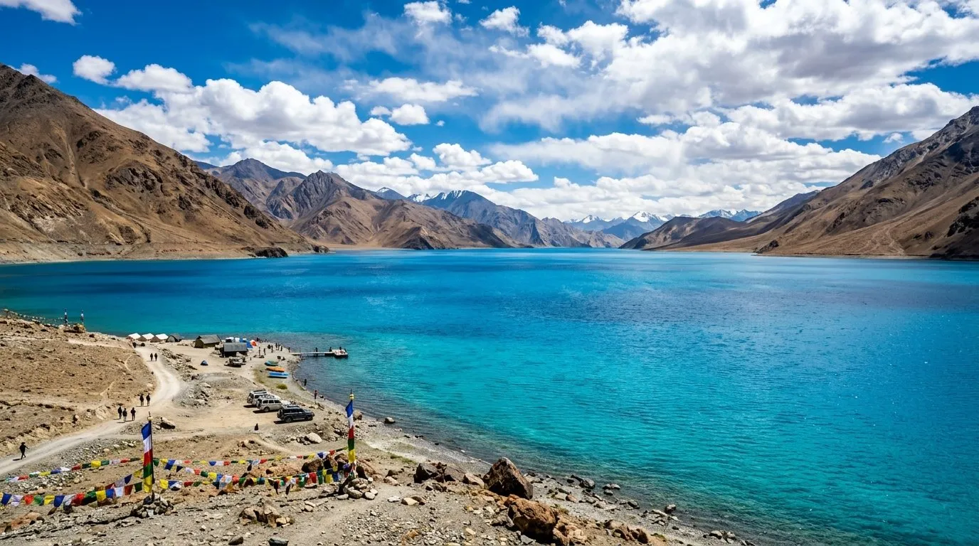
The most Instagrammed lake in India and the most dangerous for unprepared tourists — 4350m of beauty that punishes anyone who skips acclimatization.
VERIFIED JUN 2026 · ISSUE Nº 48
4 MIN READ·Or skip to the verdict ↓
“The most Instagrammed lake in India and the most dangerous for unprepared tourists — 4350m of beauty that punishes anyone who skips acclimatization.”
WHY SPECIAL
Pangong changes color from blue to green to grey through the day. It stretches 134km into China. The 3 Idiots scene was shot at Spangmik. But at 4350m, AMS is real and there is NOTHING here — no hospital, no network, no rescue.
Know before you go
Every month rated on the 0–10 editorial scale. Click any cell to read the month-specific verdict — what to do, what to skip, what crowds you'll meet.
↑ Tap any month for the full read · colours match verdict bands
Read our scoring methodology →
DEEP-DIVE READS
ELEVATION
Pangong changes color from blue to green to grey through the day. It stretches 134km into China. The 3 Idiots scene was shot at Spangmik. But at 4350m, AMS is real and there is NOTHING here — no hospital, no network, no rescue.
Before you decide
Here's what they miss.
At least now you know what's out there.
If
You develop a mild headache, nausea, dizziness or loss of appetite above roughly 2,500m within 6–24 hours of arrival.
Then
Stop ascending. Rest at the current altitude for 24–48 hours. Hydrate aggressively. If symptoms worsen or fail to improve, descend 500m and seek medical help. Never ascend further while symptomatic — HAPE and HACE kill quietly.
Full protocol →
If
Your UPI apps return Server Error or Bank Unavailable repeatedly, and no card reader is in sight.
Then
This is the default state in most border valleys, not an emergency. Carry at least ₹10,000 cash in mixed denominations for any trip above 2,500m or off a state highway. Withdraw at the LAST reliable ATM — usually the district HQ — because village ATMs are ornamental.
Full protocol →
Every destination carries trade-offs. The cards below score the practical ones: confidence in the data, kids-suitability, solo-female read, and the emergency floor.
Leh 150km via Chang La 5360m. 5hrs rough drive.
Road: Rough, unpaved sections. Chang La is extreme.
Public transport: Shared taxis from Leh.
Self-drive: 4WD essential. Fuel up in Leh.
15 options (camp, basic tent)
₹1000-4000/night
Through Leh operators. Walk-in risky (may be full).
Emergency: Camps will accommodate but facilities are basic.
Nearest: Karu (100km back toward Leh)
Next: Leh
⚠ Carry extra fuel (20L jerry can recommended)
EV charging: Not available
Freezing EVERY night even July. At 4350m oxygen is 58% of sea level. AMS is the real danger.
Hospital: NOTHING. Nearest: Leh 5hrs.
Police: Army checkpoints
Rescue: Army. No civilian rescue.
Ambulance: None. Army helicopter in extreme emergency (weather permitting).
Helpline: No civilian helpline. Carry satellite phone or PLB.
WiFi: None
ZERO SIGNAL. No phone, no internet, no SOS. You are completely on your own. Download everything. Tell someone your plan.
KIDS · FAMILY READ
REASONS
CONCERNS
At 4350m, oxygen is 58% of sea level. Children are at severe AMS risk. Zero medical facilities. No phone signal. 5-hour rough drive each way.
Day or overnight from Leh — Ladakh Tourism-registered camps. Solo-women routine on organised trip. Don't sleep in unregistered camps.
Pangong Tso is a stunning 134 km long lake at 4350m altitude, straddling the India-China border. Made famous by the Bollywood film '3 Idiots.' The lake changes color from blue to green to red through the day. Sensitive military zone — Chinese border is close.
Heavy warm layers — extremely cold, especially at night and early morning. UV protection essential. Wind protection critical.
Very basic tent camps and dhabas along the lake. Food quality is inconsistent. Carry your own snacks, water, and emergency food from Leh (160 km). Altitude suppresses appetite but stay hydrated.
Cash only. No ATMs within 160 km. Carry all cash from Leh.
Very low. Camp operators speak basic Hindi. Army personnel at checkpoints speak English.
No mobile coverage at all. No BSNL, no Jio, no Airtel. You are completely offline. Download offline maps. Inform someone of your itinerary before departing Leh.
Delhi — over 1200 km. Nearest medical: Leh Army Hospital (160 km). AMS is a serious risk at 4350m — acclimatize in Leh minimum 2-3 days. Carry Diamox (consult doctor before trip).
Inner Line Permit (ILP) required. Foreign nationals need Protected Area Permit (PAP). Multiple army checkpoints will verify permits. Do not photograph military installations.
EMERGENCY · SOURCE-VERIFIED
13,862 ft (4,225 m) की ऊँचाई पर 134 km लंबी अद्भुत endorheic झील। रंग बदलती रहती है — नीले से फ़िरोज़ी और हरे तक।
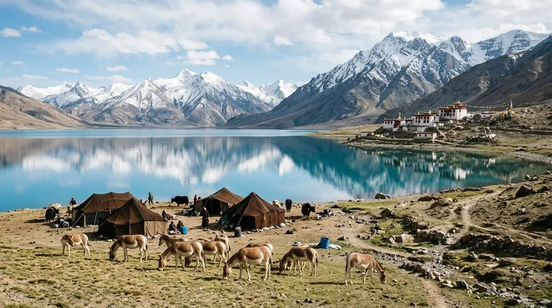
Pangong Lake के किनारे Changpa घुमंतू समुदाय की बस्तियाँ। याक के बालों से बने पारंपरिक तंबू और अनूठी संस्कृति।
NEIGHBOURHOODS · WITHIN PANGONG TSO
Pangong पर आगे — जहाँ पर्यटक आना बंद हो जाते हैं और झील और नीली हो जाती है
Man, Spangmik से Pangong के दक्षिणी किनारे पर 30 km आगे है। झील का रंग नाटकीय रूप से बदलता है। कम पर्यटक, पास में Changpa खानाबदोश शिविर। सादे होमस्टे।
दुनिया के सबसे ऊँचे दर्रों में से एक — जहाँ आपकी कार का इंजन मरता-सा लगता है, और शायद आप भी।
Chang La (5360m) Leh से Pangong जाने का रास्ता है। भारतीय सेना शीर्ष पर एक कैफ़े चलाती है। ऊँचाई का असर तेज़ होता है — थोड़े समय के लिए रुकें, फ़ोटो लें, आगे बढ़ें। रुकें नहीं।
Pangong का पहला व्यूपॉइंट — जहाँ नीला पहली बार आपको चौंका देता है
Spangmik, Pangong के दक्षिणी किनारे पर पहली बस्ती है। यहाँ अधिकांश पर्यटक रुकते हैं, 3 Idiots का दृश्य फिल्माया गया था, और झील का पहला नीलापन दिखता है। कैंपिंग और साधारण होमस्टे उपलब्ध।
HIDDEN GEMS · 3 NEAR PANGONG TSO
99% go to north bank (3 Idiots point). South bank requires separate permit.WHY NOBODY KNOWS
Same lake, completely empty. Deeper blue-green. 40km of lakefront without another vehicle. 1962 war memorial.
A Changpa nomadic settlement on the eastern shore of Pangong, 30 km past Spangmik, where the lake water actually meets shore without a row of pre-fab tents in front of it. Mud-brick homes, a 17th-century gompa above the village, and the Inner Line Permit checkpoint that turns most travellers around at Spangmik so the road past it stays nearly empty. Best: May to September; July-August for warmest day temperatures. Reach: 30 km east of Spangmik along the south bank of Pangong; 1 hour from Spangmik on rough road, 7 hours total from Leh; carry ILP for Merak (separate from standard Pangong ILP). Tip: Confirm ILP includes Merak when applying in Leh. Homestays via Peaceful Homestay Merak. No fuel stations past Tangtse — fill up there. Cell signal: BSNL only..
A small high-altitude lake at roughly 4,800m near Chushul, 55 km south of Pangong, that almost no tour operator includes. No tents, no signs, no shops — just the lake, the wind, and the bowl of mountains around it. Sees fewer than fifty visitors a month even in peak season according to local Chushul homestay operators. Best: June to September; July is the only fully reliable month. Reach: 55 km south of Pangong via Chushul; 2 hours from Merak on broken road, requires high-clearance vehicle and Chushul ILP from Leh DC office; arrange overnight in Chushul homestay. Tip: Acclimatise in Leh and Spangmik first — direct ascent risks AMS. Carry petrol can. Diamox 250mg morning of, hydrate aggressively. No cell signal — file route with hotel before leaving..
OR INSTEAD · NEIGHBOURING READS
How Pangong Tso stacks against the closest alternatives.
WHAT A DAY ACTUALLY COSTS
Iconic lake at 4350m; 5-6hr drive from Leh; homestays at Spangmik/Man; no luxury; carry warm gear; permits needed
WHAT CROWDS LOOK LIKE
3 Idiots fame made it iconic. Jul-Aug sees tent city at Spangmik. Permit required. Accessible only Jun-Sep. Altitude 4350m limits many.
INFRASTRUCTURE · ON THE GROUND
Leh Taxi Union sets all rates. Day trip Leh-Pangong-Leh: ₹8000. Leh-Pangong overnight (2 days): ₹14,000. Leh-Pangong-Nubra-Leh (direct Shyok route, 3 days): ₹22,000. Leh-Pangong-Tso Moriri-Leh (4 days): ₹32,000. Motorbike rentals from Leh: ₹1500–2000/day (Himalayan recommended). No Ola/Uber. Shared sumos from Leh to Pangong are rare and slow.
Homestays accept arrival from afternoon. Infrastructure is basic: solar/generator power, bucket-hot-water showers, Indian-style toilets, thick blankets. Do not expect Wi-Fi or hot showers on demand. Dress layered — sunny 15°C by day, -5°C by night is common even in summer. ILP mandatory (apply Leh DC office or lahdclehpermit.in, 48h ahead). Foreigners need PAP via registered tour operator.
Cash only throughout. UPI does not work — no reliable signal. Homestay rates ₹1500–3000/person/night including meals. Dhaba food ₹200–400/meal. Carry ₹8000+ for a 3-day Pangong trip beyond your pre-paid taxi/homestay.
No ATMs anywhere near Pangong. One ATM at Tangtse (30km before Spangmik) that works ~40% of the time. Cash plan: withdraw at Leh before leaving.
Pangong is not a town, it's a string of small villages. Spangmik has ~6 homestays and 3 dhabas. Man has 2 homestays. Merak has 1. Tourist infrastructure May–Sep only; everything shuts in winter (homestay owners migrate to Leh/Kharu). No shops for supplies — stock up in Leh.
Ladakhi (Changskhat dialect at Pangong) + Hindi. Most homestay owners speak functional English — they host international tourists half the year. Changpa nomads speak Ladakhi and some Hindi, minimal English. Foreigners rarely face language issues with homestay hosts.
Only BSNL has any signal near Pangong, and only at Spangmik village at erratic 2G speeds. Most homestays have no Wi-Fi. Satellite phones are rare but some operators carry them. Assume complete disconnection. Download offline maps + medical emergency protocol before leaving Leh.
HOW TO REACH
AIRPORT
Leh (150km)
RAIL
None
WHERE TO EAT · 7 VERIFIED PICKS
Signature: 14,200 फुट पर गरम सूप के साथ बुफे रात का खाना
Spangmik के ऊपर एक ऊँची कगार पर 15 डीलक्स तंबुओं और एक समर्पित भोजन तंबू के साथ। समीक्षक लगातार रसोई की प्रशंसा करते हैं जो अनुरोध पर तंबुओं तक गरम सूप भेजती है — ऊँचाई पर उपयोगी जब मेहमान कम खाते हों।
Tip: असली झील किनारे से दस मिनट की पैदल दूरी — दूसरी रात इस सूप-टु-टेंट सेवा का उपयोग करें जब आप अनुकूलन कर रहे हों और बिस्तर छोड़ना न हो।
Signature: Chang-La उतरने के बाद बुफ़े रात का भोजन
Tangtse गाँव (झील से 30-40 किमी पहले) Leh से देर से आने वाले या Nubra से Shyok के रास्ते लौटने वाले समूहों के लिए Chang-La के बाद का मानक पड़ाव है। होटल का भोजन कक्ष दो घंटे की सूचना पर बाहरी समूह बुकिंग लेता है — इस रास्ते पर एकमात्र ऐसी बुफ़े रसोई।
Tip: बिजली केवल रात 7-11 बजे चलती है; अंधेरे में पड़ने से बचने के लिए 10:30 बजे से पहले रात का भोजन करें। Pangong से वापस आते समय यह वह दोपहर के भोजन का पड़ाव है जो Durbuk जंक्शन के महँगे ढाबों से बेहतर है।
Signature: सब्ज़ी मनचाऊ सूप और फ़्राइड राइस कॉम्बो
85 से अधिक समीक्षाओं में TripAdvisor पर Lukung का #1-रैंक शिविर। Lukung झील का प्रवेश बिंदु है — Chang-La से उतरने के बाद पहले नज़र आता है — इसलिए यह भोजन तंबू अक्सर वह जगह है जहाँ सड़क-यात्री अपना पहला पांगोंग दोपहर का भोजन करते हैं।
Tip: अगर लेह → पांगोंग → लेह एक दिन में (लंबा लेकिन संभव) कर रहे हैं, तो Lukung का दोपहर भोजन Spangmik से तेज़ है। 15 किमी अधिक Spangmik जाने की जगह यहाँ रुकें; खाने का स्तर समान है।
Signature: झील-नज़ारे के साथ तिब्बती थुपका
Pangong किनारे पर कुछ स्वतंत्र (गैर-शिविर) रेस्तरांओं में से एक — अधिकांश झील पर भोजन शिविर पैकेज में बंद है। P3 वॉक-इन लेता है, झील के नज़ारों के साथ उचित भोजन हॉल है, और रसोइया Padam पहले गोवा में नौ साल काम कर चुके हैं।
Tip: Leh से दिन-यात्रियों को दोपहर का खाना ढूँढने में मुश्किल होती है जो केवल-शिविर न हो — P3 उत्तर है। 6+ के समूह के लिए +91 94197 05278 पर पहले से फोन करें ताकि वे बुफे तैयार कर सकें।
Signature: ऊँचाई पर ताज़ा पकाई शाकाहारी थाली
स्पांगमिक का सबसे पुराना संगठित कैम्प रेस्तरां — 25 तंबू, 50 सीटों का भोजन कक्ष, बहु-व्यंजन रसोई, जैन रसोइया। TripAdvisor पर 98+ समीक्षाओं के साथ स्पांगमिक का #1 लॉज।
Tip: भोजन केवल यहाँ रुके मेहमानों के लिए पैकेज में — मुख्य मौसम में बाहरी लोगों को नहीं परोसा जाता। यदि आप यहाँ रुके हैं, तो मानक भारतीय बुफ़े की बजाय लद्दाखी थुपका माँगें — वही रसोई, कम सामान्य।
Signature: मिट्टी-ईंट के भोजन कक्ष में शाकाहारी बुफ़े
75 सीटों वाले स्थायी मिट्टी-ईंट के भोजन कक्ष के आसपास बना — उस क्षेत्र में दुर्लभ जहाँ भोजन का मतलब आमतौर पर फड़फड़ाता टेंट होता है। Spangmik से आगे Maan गाँव (झील के किनारे पर और आगे) से झील तक पाँच मिनट की पैदल दूरी, इसलिए भोजन-पड़ाव शांत किनारे का दृष्टिकोण भी बन जाता है।
Tip: केवल शाकाहारी। गुजराती थाली वह है जिसे अधिकतर मेहमान कम ऑर्डर करते हैं; पहुँचने की रात रसोई से कहें कि मानक बुफ़े की जगह वही दे, विशेष रूप से अगर तीन दिन से दाल-चावल पर हैं।
WHERE TO SLEEP · EDITOR'S PICKS
Family-run Homestay
Man गाँव में झील से 200 मीटर पर चार कमरों वाला बुटीक होमस्टे — बुख़ारी हीटिंग, जैविक रसोई, परिवारिक मेज़बान। पता: Man village, Pangong Lake, Leh District, Ladakh 194201. फ़ोन: +91 94197 05278।
High-altitude Glamping
Man गाँव में छह झील-सामना कमरे — 'Three Idiots' फ़ोटो-स्टॉप 8 किमी दूर है, झील दरवाज़े पर है। पता: Man village, Pangong Lake, Leh District, Ladakh. फ़ोन: +91 70062 68226।
Luxury Lodge
Pangong में प्रवेश करते ही Lukung में पहली झील-सामना संपत्ति — 94 समीक्षाओं में मिश्रित आराम, लेकिन गाँव में सबसे वैध झील के किनारे होटल नाम। पता: Pangong Lake, Lukung village, Leh District, Ladakh 194101।
Mid-range Resort
Spangmik में Eco Travellers Camp (अक्सर Lukung पिनकोड 194101 के तहत सूचीबद्ध) Pangong के दक्षिण-पश्चिम किनारे पर सीधे दस्तावेज़ीकृत तंबू विकल्प है। तंबू साधारण हैं — ऊँचे मंचों पर गद्दे, संलग्न पश्चिमी शौचालय, सौर लैंप, भोजन के लिए केंद्रीय ढाबा तंबू — लेकिन सामने की झील की स्थिति ही रात भर Pangong पर रहने का कारण है। संचालन केवल मई-अक्टूबर।
“आपके तंबू द्वार से झील पर पहली रोशनी, Leh से दिन-यात्रा जीपें लगभग 11 बजे आने से पहले।”
BOOK A STAY · CURATED PROPERTIES
हम बुकिंग से पहले आते हैं, उसके साथ नहीं — नीचे दिए प्लेटफ़ॉर्म पर दाम की तुलना करें।
किसी भी जगह, ठहरने या ऑपरेटर को दिखाने के लिए हम पैसे नहीं लेते। यहाँ दिए किसी लिंक से बुकिंग करने पर हमें थोड़ा कमीशन मिल सकता है, आप पर कोई अतिरिक्त खर्च नहीं। इससे हमारे स्कोर या सुझावों पर कभी असर नहीं पड़ता। संपादकीय नीति
LOCAL LEGENDS · WHO MAKES THIS PLACE
One of the first to set up camps at Pangong when 3 Idiots made it famous. His tents are basic but his stories about the lake changing 7 colors at different times are poetic. Makes sure every guest sees the Milky Way.
FESTIVALS · BY THE MONTH
Celebration of Changpa nomadic culture near Pangong Tso with pashmina goat herding demonstrations, butter tea ceremonies, and traditional Changpa tent exhibits.
Real experiences by traveler type — not generic star ratings
The color of the water changes from azure to turquoise to deep blue depending on the light angle. Sunrise is the best — the mountains behind the lake turn pink then gold while the water is perfectly still. The 3 Idiots fame has brought tourists but walk 1km along the shore and you are alone.
💡 Tip: Stay overnight at a camp on the lake shore. The night sky reflected in Pangong with the Milky Way is the most extraordinary thing I have ever photographed.
Watching the lake change colors together as clouds moved across the sky — we sat for 3 hours just watching. The drive from Leh through Changla Pass is long (5 hours) but the moment you see the lake it is all worth it. We stayed in a lakeside camp — sleeping with that water 20 meters away was surreal.
💡 Tip: Stay overnight. Most tourists come for 2 hours and leave. The sunset and sunrise on the lake are the real experiences.
The drive from Leh is exhausting — 5 hours one way over Changla Pass at 5360m. The lake itself is unlike anything I have ever seen — the blue is almost artificial-looking. Altitude headache hit me hard. Carry Diamox, paracetamol, and lots of water. The camps are basic but adequate.
💡 Tip: Do not attempt Pangong on your first or second day in Leh. Acclimatize for at least 2 days in Leh first.
The ride from Leh to Pangong via Changla is a rite of passage for bikers. The road is surprisingly good now — paved most of the way. Changla at 5360m will test your body and your bike. The descent toward the lake when you first see that blue — there is no feeling like it on a motorcycle.
💡 Tip: Carry oxygen cans from Leh. At Changla Pass altitude, some riders get severely affected. Do not push through — stop and breathe.
Exit Leh by 4:30am. Chang La pass (5360m — 3rd highest motorable pass in India) reached by 8am. 15 min photo stop, no longer — altitude. Push through to Tangtse (permit checkpoint, ILP verified here).
First glimpse of Pangong at Lukung (the entry point to the lake). Drive the lakeshore 10km to Spangmik — the village with the famous 3 Idiots filming location and the scooter-shot viewpoint. Lunch at a basic dhaba in Spangmik (maggi, dal rice). Avoid the tourist trap 'Three Idiots Point' set up near the lake — it's ₹50 to sit on a plastic scooter for a photo.
Walk the lakeshore. Pangong's colour shifts real-time with sun angle — turquoise at noon, indigo by 3pm, purple at sunset. Do not wade in — water is brackish (salt lake, not fresh) and shockingly cold. Return via Tangtse by 3pm to clear Chang La before afternoon weather closes it.
Back in Leh by 8–9pm. 14-hour day total. This is the most punishing one-day trip in Indian tourism and only advisable if you've had 3+ days acclimatizing at Leh.
If weather turns
Chang La pass closes without warning in summer rain or winter snow. If closed morning-of: reschedule for the next day, don't try the Shyok-Nubra alternative as a substitute (it's a different multi-day trip). If stuck at Pangong overnight: homestays in Spangmik and Man are basic but available; carry cash and warmers.
Tap any traveler type below to see how this place feels for them.
Hard no with young kids. 4350m is pediatric-unsafe for under-12s even with acclimatization. For 13+ teens who've already acclimatized at Leh for 3+ days: possible as a day trip, not overnight. Homestay conditions (cold, basic, shared bathrooms) are a test of adaptability even for adults.
Best for
Pangong is the emotional and visual peak of any Ladakh trip. Not technically the highest-altitude thing you'll do, but the single most iconic landscape — the one photo everyone expects you to come back with.
Best for
Saltwater high-altitude lakes exhibit a rare real-time colour shift as the sun moves. Pangong's 134km length and angle to the sun make it the most extreme example in India — genuine every-hour-it-looks-different territory.
Best for
No city within 400km. Zero light pollution. High altitude = thin atmosphere. Moonless nights at Pangong deliver some of the best Milky Way shots in India. Pair with Hanle (200km south) for the full serious astro circuit.
Best for
Chang La at 5360m is ONE of the highest motorable roads in India (the Khardung La vs Umling La debate continues). The ride down to Pangong after the pass is among the most cinematic descents in motorcycling.
ALSO ON NAKSHIQ
Guides
Everything the guidebook won't tell you — written for India in 2026.
Blog
Long-form reads on regions, festivals, and the offbeat circuit.
Road trips
Driving itineraries with day-by-day stops, distance, and difficulty.
Collections
Wettest places. Sacred lakes. Solo-female-safe. Curated cuts.
NakshIQ 100
India's highest-scoring places, ranked across all 12 months.
The Window
One honest spread, every Sunday. The full back catalogue.
Skip list
Overhyped places with honest alternatives.
First trip
Safety, scams, what to wear, food survival, solo female travel.
FEATURED IN COLLECTIONS
If you are planning to ask the question, these locations have the setting, the privacy, and the emotional weight. Scored not for tourism but for a single, unrepeatable moment.
These are the stretches where the gap between petrol pumps can kill your trip. Distances, locations, and backup plans.
Frozen, turquoise, sacred, or all three. India's high-altitude lakes sit where humans have no business being — and they're worth every gasping breath.
If your idea of romance is not sharing a traffic jam on Mall Road with 10,000 other couples, these destinations offer genuine intimacy — quiet valleys, private cottages, meals by firelight, and zero Instagram influencers staging photos in matching outfits.
Near-zero light pollution. Milky Way visible to naked eye.
ROAD TRIPS THROUGH HERE
— The NakshIQ editors
TRAVELLERS' VOICE
SHARE YOUR EXPERIENCE
ASK A QUESTION