Complete Guide to Sinthan Top
Kashmir's newest mountain pass connecting Anantnag to Kishtwar at 3,748m
Destinations in this article
Why Go
Sinthan Top is a mountain pass at 3,748m connecting Anantnag (Kashmir Valley) to Kishtwar (Jammu division). The road was a military track for decades — it opened to civilian vehicles in stages starting around 2020, and the surface has been improving since.
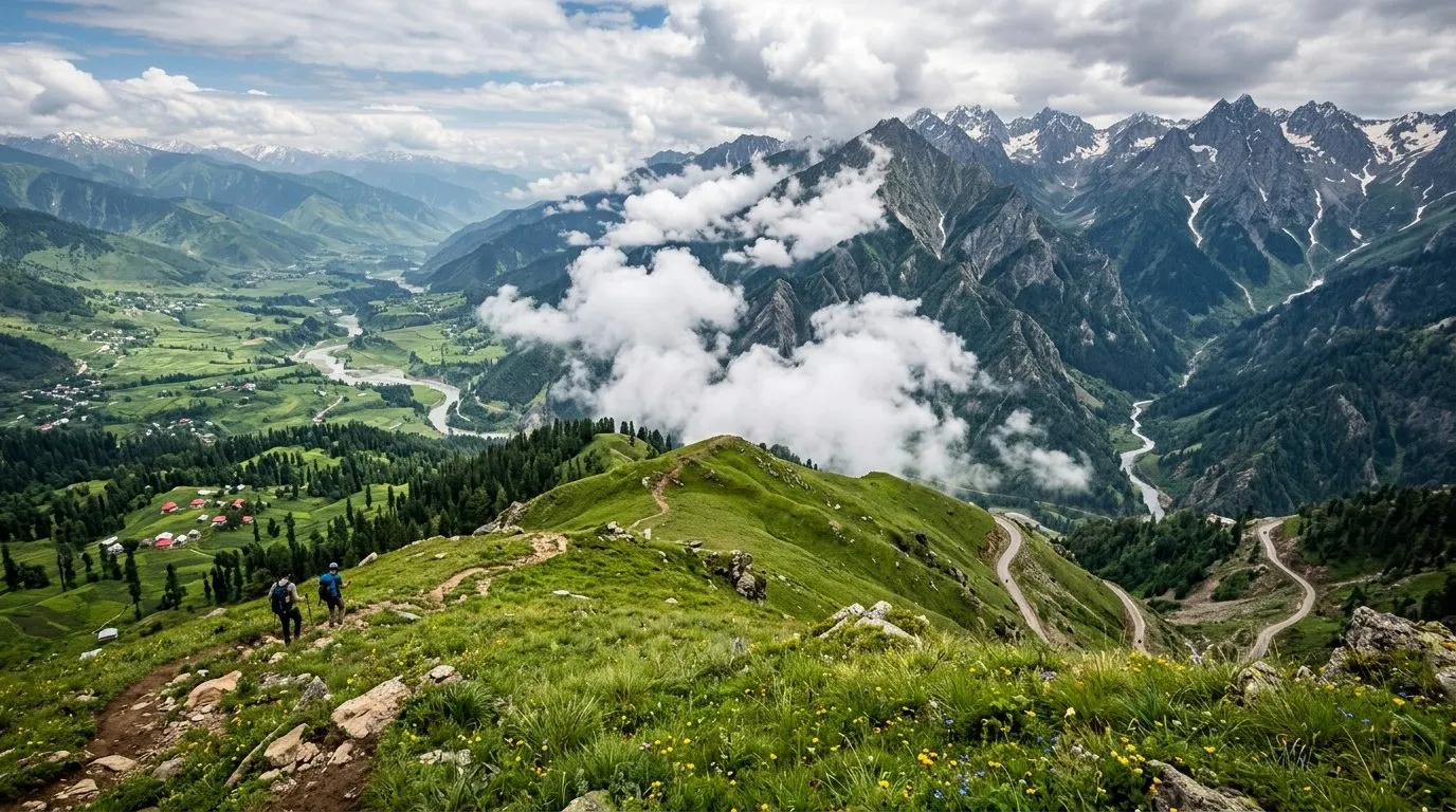
Why does a mountain pass deserve its own guide? Because Sinthan Top isn't just a crossing — it's one of the most dramatic drives in India. The ascent from Anantnag takes you through dense pine forest, alpine meadows, and then above the treeline to a barren, windswept summit surrounded by 360-degree mountain views. On clear days, you can see the Pir Panjal and the Greater Himalayan ranges simultaneously.
The pass sits on what locals call the "new Kashmir-Jammu road" — an alternative to the congested Srinagar-Jammu highway via Banihal. For travelers, it opens a route that connects the Kashmir Valley to Kishtwar, Doda, and Bhaderwah without backtracking to Jammu.
The meadows around Sinthan Top bloom spectacularly in July and August. Snow patches linger into June. The descent toward Kishtwar drops through forest and cliff-edge road into one of Jammu's most dramatic river gorges.
This is a transit experience, not a destination. You don't stay at Sinthan Top — you drive over it, possibly stop for 30 minutes to absorb the views, then continue. The value is the journey itself and the route it unlocks.
Best Month to Visit
June to September is the only window. The pass is snow-covered and closed from October through May (sometimes into early June depending on snowfall).
June is the opening month — snow walls may still line the road, which is dramatic but means conditions are unpredictable. The road surface is worst in early June after winter damage.
July-August is peak season. Meadows bloom, weather is warmest (though still cold at the summit — 5-10 degrees Celsius even in July), and the road is in its best annual condition. Monsoon rain can reduce visibility and make the road slippery, but this is when most crossings happen.
September offers the clearest skies and least rain, but the window is narrow — snow can return by late September.
Do not attempt October onwards. The pass closes without warning and you can be stranded at altitude with no shelter.
How to Get There
From Srinagar (130 km to summit, 5-6 hours): Srinagar → Anantnag → Kokernag → Sinthan Top. The road is good until Kokernag. After that, it narrows and climbs steeply. The last 30 km to the summit are steep switchbacks on a mix of tarmac and gravel.
From Kishtwar (80 km from summit, 4-5 hours): The Kishtwar side is steeper and more dramatic. The road descends through tight gorges. Surface quality varies year to year.
From Jammu (via Kishtwar, 350 km, 12-14 hours): Jammu → Udhampur → Ramban → Kishtwar → Sinthan Top. A very long day. Better to break in Kishtwar overnight.
Vehicle requirements: High-clearance vehicle recommended. A regular sedan can make it in peak season on a good year, but SUV or similar is safer. No fuel stations between Kokernag and Kishtwar — fill up before the ascent.
No public transport crosses the pass. You need your own vehicle or a hired taxi from Anantnag or Kishtwar.
Infrastructure Reality
Mobile/Internet: Zero signal at the summit. BSNL works intermittently on the Anantnag approach up to about 2,500m. The Kishtwar side has no coverage until you descend into Kishtwar town. This is a communications dead zone for 3-4 hours.
ATMs: None on the route between Anantnag and Kishtwar. Use ATMs in either town before departing.
Medical: Nothing between Kokernag and Kishtwar. No medical facility, no pharmacy, no help for roughly 100 km. This is not an exaggeration — if something goes wrong at the summit, you are hours from a hospital in either direction. Carry altitude sickness medication (Diamox), a full first-aid kit, and understand the symptoms of AMS.
Accommodation: None at the summit. Shepherd huts exist but aren't for tourists. Stay in Anantnag/Kokernag before crossing or in Kishtwar after. A few very basic dhabas appear near the pass in peak season, serving maggi and chai — don't count on them.
Food/Water: Carry your own. Fill water bottles before the ascent. Pack lunch. The dhabas at the summit are seasonal and unreliable.
Fuel: No fuel stations on the pass. Nearest on Anantnag side is Kokernag. Nearest on Kishtwar side is Kishtwar town. Distance between them: roughly 110 km of mountain road. Fill your tank completely.
Kids Verdict: 2/5
This is not a family destination. The altitude (3,748m) can cause headaches, nausea, and breathing difficulty in children. The drive is steep, winding, and hours long without stops. There are no facilities — no toilets, no restaurants, no shelter. The road can be dangerous in poor weather.
Kids 10+ who are comfortable with altitude and long mountain drives may find it exciting. Anyone younger: skip it. The risk-to-reward ratio is wrong for small children.
The Bottom Line
Sinthan Top is for travelers who value the drive as the experience. The 30 minutes at the summit — wind in your face, mountains in every direction, snow patches in summer — are genuinely transcendent. The route it unlocks (Kashmir to Kishtwar/Doda/Bhaderwah without the Jammu highway) is strategically brilliant for multi-destination trips. But respect the altitude, carry supplies, and don't attempt it outside the June-September window. This is a mountain pass, not a hill station. Prepare accordingly.
Monthly Scores
| Destination | Jan | Feb | Mar | Apr | May | Jun | Jul | Aug | Sep | Oct | Nov | Dec |
|---|---|---|---|---|---|---|---|---|---|---|---|---|
| Sinthan Top | — | — | — | — | 6.0 | 10.0 | 8.0 | 8.0 | 10.0 | 6.0 | — | — |
The Window · Every Sunday
Liked this? Get one every Sunday.
Best score of the week, one honest skip, road updates. Four minutes. No spam.
More in Field guide
Is Manali safe for solo female travellers? Which Manali, and when
Manali is not one place. New Manali is a respectable hill town — 4/5 safe. Old Manali is the Himachal backpacker-cafe strip with party + drug scene — 2/5 after 10pm. McLeodganj 3 hours away holds 5/5 year-round. Pick deliberately.
5 min read
Solo-female travel in India — every destination scored, month by month
Most India travel guides tell women 'use common sense' and call it done. We rated 488 destinations on a 1-5 scale for solo-female safety, with month-specific overrides where it matters. Here's the methodology, the top 15, and the five that don't clear the bar.
10 min read
Is Kashmir safe for solo female travellers? What actually matters
Kashmir is the destination where the generic 'is India safe for women' post fails hardest. The answer depends on which month, which valley, which houseboat operator, and whether you're willing to dress differently than you would in Goa. Here's the concrete version.
6 min read- Access
- Poor to fair. Open Jun-Oct only. Snow rest of year.
- Emergency
- None at pass · District Hospital Anantnag 85km
- Stay
- ₹N/A/night
Go with confidence.