Complete Guide to Roopkund
The skeleton lake at 5,029m — India's most haunting trek and the mystery that science still can't fully explain
Destinations in this article
Why Go
At 5,029m in the Uttarakhand Himalayas, there is a glacial lake roughly 40 metres in diameter. When the snow melts each summer, the lake reveals its contents: several hundred human skeletons (estimates range from 500 to 800) scattered around and inside the water. Some still have flesh and hair preserved by the cold. Skulls show identical fractures — circular, about the size of a cricket ball — on the top of the head.
This is Roopkund, and the skeletons have been there for over a thousand years.
The leading theory, based on carbon dating, DNA analysis, and forensic examination, is that the majority of these people died around 850 AD in a sudden, violent hailstorm. The skull fractures are consistent with large hailstones striking from directly above. A group of roughly 200+ people — possibly pilgrims on the Nanda Devi Raj Jat yatra — were caught in the open at 5,000m with no shelter. They died where they fell.
But the science isn't settled. A 2019 study published in Nature Communications found that the skeletons actually date to multiple periods — some from around 800 AD (South Asian origin), others from the 1800s (Mediterranean origin). How people of Mediterranean descent ended up at a glacial lake in the Indian Himalayas 200 years ago is a question nobody has convincingly answered.
You go to Roopkund for the trek (53km, 5-6 days, through some of Uttarakhand's most beautiful alpine meadows) and for the lake itself — a place that is genuinely, factually haunted by an event that science can describe but not fully explain.
The Best Month (and the Worst)
Best: Late May to mid-June. The snow has melted enough to make the trail passable but not enough to fully expose the lake — you get a mix of snow-covered and visible terrain. Temperatures at base camps (3,500m): 5°C to 15°C. At Roopkund (5,029m): -5°C to 5°C. The Bugyal (alpine meadows) at Ali and Bedni are carpeted in wildflowers.
Runner-up: Late September to early October. Post-monsoon clarity gives exceptional mountain views. Nanda Ghunti (6,309m) and Trishul (7,120m) are visible from the trail. Colder than May-June but stable weather.
Worst: July-August (monsoon). Heavy rain at lower altitudes, snow and whiteouts at higher elevations, leeches on the trail, and landslide risk on the access road to Lohajung. Visibility near zero at the lake. The same conditions that killed the original victims — sudden storms at altitude — are most likely during monsoon.
Also avoid: November through April. The trail is buried under several metres of snow. The lake is frozen and snow-covered — you wouldn't even know it's there. Avalanche risk on the upper slopes is high.
How to Get There
Trailhead: Lohajung (2,500m)
Getting to Lohajung:
- ●Fly to Dehradun (Jolly Grant Airport, 1hr from Delhi, ₹3,000-8,000). Drive Dehradun → Rishikesh → Karnaprayag → Dewal → Lohajung (approximately 280km, 10-12 hours by road). The last 100km from Karnaprayag is winding mountain road.
- ●Alternative: Train to Kathgodam (Nainital line) → Drive to Lohajung (approximately 250km, 10-11 hours). Marginally shorter but the road quality is similar.
- ●Shared jeeps run from Dewal to Lohajung (last 30km) for about ₹300-500 per seat.
The Trek: Lohajung → Roopkund → Lohajung (53km, 5-6 days)
Standard itinerary:
- ●Day 1: Lohajung (2,500m) → a Didna village homestay (operator-booked)ge (2,745m) — 9km, 4-5hr
- ●Day 2: Didna → Ali Bugyal (3,400m) — 11km, 5-6hr. This is where the landscape shifts from forest to alpine meadow.
- ●Day 3: Ali Bugyal → Ghora Lotani (3,910m) → Bhagwabasa (4,250m) — 10km, 5-6hr. Above treeline now.
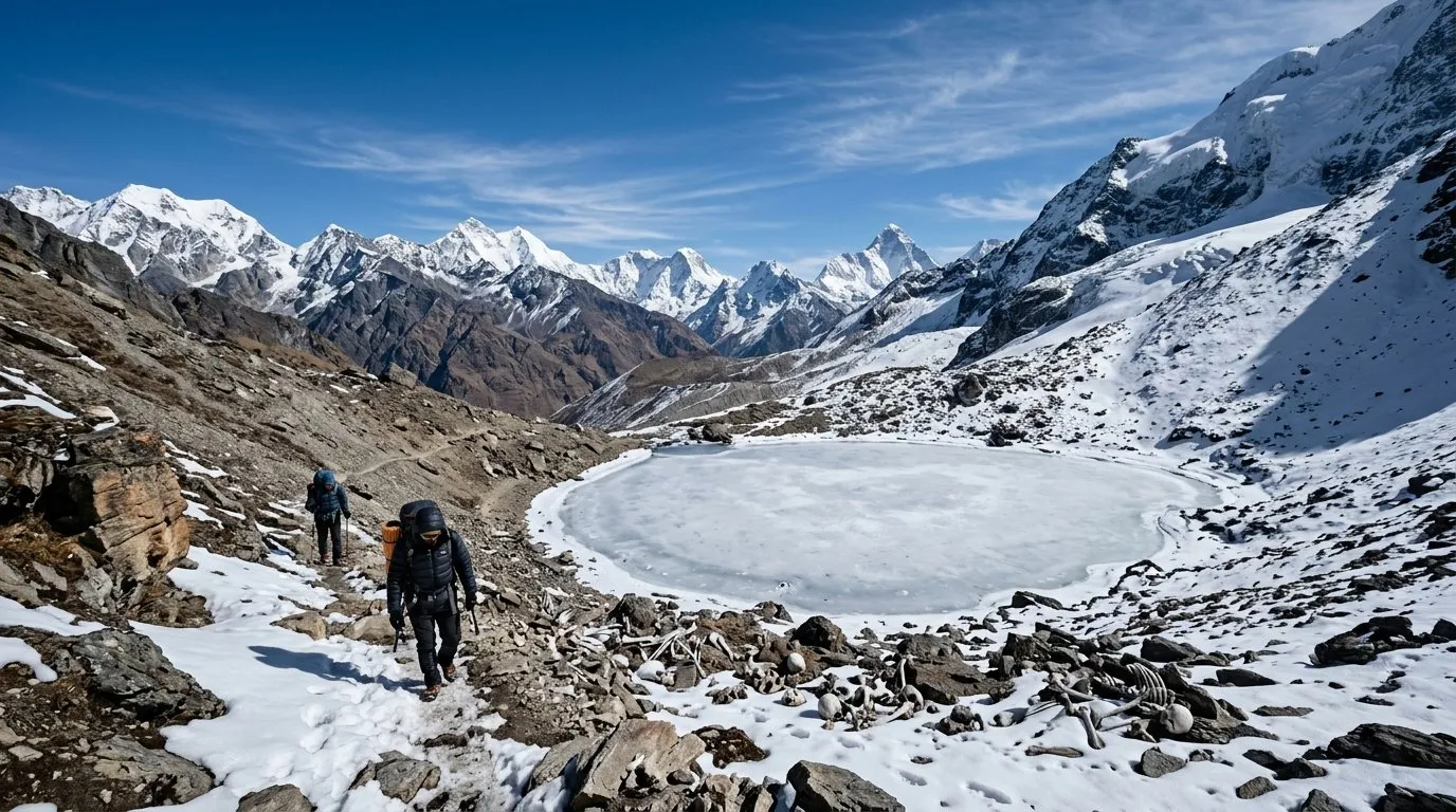
- ●Day 4: Bhagwabasa → Roopkund (5,029m) → Bhagwabasa — 6km round trip, 5-7hr. Summit day. The climb from Bhagwabasa to Roopkund gains 780m in 3km — steep, rocky, and often snow-covered.
- ●Day 5: Bhagwabasa → Bedni Bugyal → a Wan village homestayge (2,440m) — 17km, 7-8hr. Descent via alternate route.
- ●Day 6 (if needed): Buffer day or walk from Wan to Lohajung.
What to Expect
The first two days are pleasant — forested trails, a charming village (Didna), and the gradual revelation of Ali Bugyal, one of the largest alpine meadows in India. Ali Bugyal at 3,400m is a vast, rolling grassland surrounded by snow-capped peaks. It's genuinely one of the most beautiful camping spots in the country.
From Day 3, it gets harder. The treeline ends, the temperature drops, and the altitude makes every step heavier. Ghora Lotani to Bhagwabasa is exposed and windy. Bhagwabasa itself is a grim campsite — rocky, cold, and functional. You sleep here specifically because it's the closest feasible camping spot to Roopkund.
Summit day is the crux. You leave Bhagwabasa at 3-4 AM to reach the lake by sunrise. The trail is steep scree and snow. At 4,500m+, you're breathing hard with every step. The last 200m of elevation gain is the hardest — loose rock, possible ice, and the altitude pressing on your lungs.
Then you see the lake. It's smaller than you expect. And if the snow has melted sufficiently, you see the bones — scattered around the shore, some partially submerged, some bleached white, some still disturbingly intact. The skulls with their round fractures are immediately visible. It is one of the most unsettling places you will ever stand.
Infrastructure Reality
Medical: There is nothing on the trail. The nearest hospital is in Tharali, approximately 4 hours by road from Lohajung. From the upper camps (Bhagwabasa, Roopkund), evacuation to the trailhead takes 1-2 days on foot. Helicopter evacuation is theoretically possible from Bedni or Ali Bugyal (flat meadows) but requires advance arrangement and costs ₹3-5 lakh. Carry altitude sickness medication (Diamox), painkillers, bandages, antiseptic, and any personal medications.
Money: Carry all cash from Rishikesh or Dehradun. There is an ATM in Dewal (the last town before Lohajung) but it's unreliable. Budget ₹3,000-5,000/day if using a guide service (which you should). This covers guide fees, porter charges, camping equipment, and food.
Communication: No mobile network above Lohajung. Some BSNL signal in Lohajung itself (weak). Your satellite communicator or your guide's sat phone is your only link to the outside world on the trail.
Water: Stream water is available at most campsites but should be purified. Carry purification tablets. Above Bhagwabasa, water sources may be frozen — carry at least 2L from camp.
Permits: The Uttarakhand government has periodically restricted access to Roopkund to protect the site and reduce environmental damage. As of the last update, permits are required and group sizes are limited. Check the current permit status with the Uttarakhand Forest Department before booking anything. Rules have changed multiple times in recent years.
Where to Stay
On the trek, you're camping. Your guide/operator provides tents, sleeping bags (verify they're rated to -10°C minimum), and cooking equipment.
Lohajung (before and after the trek):
- ●Guesthouses: ₹500-1,000/night. Basic rooms. Hot water if you're lucky (ask before booking).
- ●a trek-operator's basecamp in Lohajung (yes, really): the most established option, ₹800-1,200/night.
- ●Homestays: ₹300-500/night. More authentic, usually includes meals.
Campsites on the trek:
- ●Didna: Flat ground near the village, sheltered.
- ●Ali Bugyal: Beautiful, exposed meadow. Can be windy. Spectacular sunrise views.
- ●Bedni Bugyal: Similar to Ali but with a small temple (Bedni Kund).
- ●Bhagwabasa: Rocky, cold, utilitarian. You're here for proximity to the summit, not comfort.
Kids Verdict
Rating: 1/5 — No.
Roopkund's summit sits at 5,029m — well into the zone where altitude sickness becomes dangerous for adults, let alone children. The trek involves 6 days of hiking in remote wilderness with zero medical infrastructure. The final summit push involves steep, icy, loose terrain at extreme altitude. Children should not attempt this.
Teenagers 16+ with prior trekking experience at 3,000m+ and good fitness could potentially attempt the trek up to Bedni Bugyal (3,500m) as a shorter itinerary. Going above 4,000m with anyone under 16 is irresponsible.
The skeletons, for what it's worth, are not particularly disturbing visually — they're ancient and weathered. The existential dread is more of an adult experience.
What to Avoid
- ●Going without a guide. The trail above Ali Bugyal is not well-marked, and in fog or snow, route-finding becomes dangerous. A fall on the Roopkund summit approach can be fatal. Use a reputable trekking company (Indiahikes, Trek the Himalayas, or Bikat Adventures are established names).
- ●Skipping acclimatization. The itinerary is designed with altitude gain in mind. Do not compress it. If your operator offers a 4-day "fast" itinerary, say no.
- ●Taking the monsoon window. The same hailstorms that killed people 1,200 years ago still happen. Monsoon weather at 5,000m is violent and unpredictable.
- ●Touching or moving the skeletons. This is an archaeological site. It is also potentially a crime. Look, photograph, and leave everything exactly as it is.
- ●Ignoring permit requirements. If the trek is restricted when you plan to go, do not try to sneak in. Fines are steep, and the restrictions exist to preserve the site.
- ●Underestimating the descent. Knees take a beating on the way down. Trekking poles are essential, not optional.
The Bottom Line
Roopkund is not the most beautiful trek in India (that's probably Hampta Pass or Valley of Flowers). It's not the hardest (Chadar or Stok Kangri claim that). What Roopkund has is something no other trek offers: a destination that raises questions about human history that the best scientists in the world cannot fully answer.
You hike for 5 days through forests and meadows, you climb to 5,029m in the pre-dawn dark, and you find 500 skeletons at a frozen lake. The physical challenge is significant — this is a hard trek by any standard. But the psychological impact of standing at Roopkund, looking at the bones, and thinking about what happened there in 850 AD (or whenever it happened) stays with you longer than the sore legs.
This is a trek for people who want more than scenery. If that's you, Roopkund delivers.
Monthly Scores
| Destination | Jan | Feb | Mar | Apr | May | Jun | Jul | Aug | Sep | Oct | Nov | Dec |
|---|---|---|---|---|---|---|---|---|---|---|---|---|
| Roopkund | — | — | — | 2.0 | 8.0 | 10.0 | 4.0 | 2.0 | 6.0 | 8.0 | 2.0 | — |
The Window · Every Sunday
Liked this? Get one every Sunday.
Best score of the week, one honest skip, road updates. Four minutes. No spam.
More in Field guide
Is Manali safe for solo female travellers? Which Manali, and when
Manali is not one place. New Manali is a respectable hill town — 4/5 safe. Old Manali is the Himachal backpacker-cafe strip with party + drug scene — 2/5 after 10pm. McLeodganj 3 hours away holds 5/5 year-round. Pick deliberately.
5 min read
Solo-female travel in India — every destination scored, month by month
Most India travel guides tell women 'use common sense' and call it done. We rated 488 destinations on a 1-5 scale for solo-female safety, with month-specific overrides where it matters. Here's the methodology, the top 15, and the five that don't clear the bar.
10 min read
Is Kashmir safe for solo female travellers? What actually matters
Kashmir is the destination where the generic 'is India safe for women' post fails hardest. The answer depends on which month, which valley, which houseboat operator, and whether you're willing to dress differently than you would in Goa. Here's the concrete version.
6 min read- Access
- Rough mountain road to Lohajung via Karnaprayag. Last 50km very bad. Then multi-day trek
- Emergency
- Not available on trek. Helicopter evacuation only (weather dependent) · No medical facility for 3+ days on trek. Lohajung PHC first aid only. District Hospital Chamoli — 100km
- Stay
- ₹500-1000/night at Lohajung. Trek camps included in operator fee – 15000-25000 for full 8-day trek package all inclusive/night
Go with confidence.