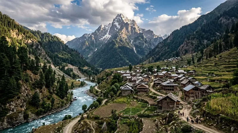
Bangus Valley First Meadow Trek.
Bangus has no road. The trek to the first meadow is ~3hrs.WHY NOBODY KNOWS
First meadow of Asia second-largest high-altitude meadow. Wildflowers in July. Total solitude.
DISPATCH · ISSUE Nº 48
A permit-required frontier valley near the LoC that rewards the bureaucratic effort with meadows nobody else is standing in.
VERIFIED APR 2026 · ISSUE Nº 48
4 MIN READ·Or skip to the verdict ↓
“A permit-required frontier valley near the LoC that rewards the bureaucratic effort with meadows nobody else is standing in.”
WHY SPECIAL
Bangus is a massive alpine meadow in Kupwara district near the LoC. No road — you trek in. DC Kupwara permit required. Few facilities, zero tourists. One of the last genuinely untouched meadow valleys in Kashmir.
PEAK CROWDS
June is बांगस घाटी's busiest window. The score rates conditions — weather, access, value — not how many people you'll share them with. Remote high-altitude valley accessible Jun–Sep when snow melts; winter closure and permit restrictions limit offseason visits.
Know before you go
Every month rated on the 0–10 editorial scale. Click any cell to read the month-specific verdict — what to do, what to skip, what crowds you'll meet.
↑ Tap any month for the full read · colours match verdict bands
Read our scoring methodology →
ELEVATION
Bangus is a massive alpine meadow in Kupwara district near the LoC. No road — you trek in. DC Kupwara permit required. Few facilities, zero tourists. One of the last genuinely untouched meadow valleys in Kashmir.
If
You develop a mild headache, nausea, dizziness or loss of appetite above roughly 2,500m within 6–24 hours of arrival.
Then
Stop ascending. Rest at the current altitude for 24–48 hours. Hydrate aggressively. If symptoms worsen or fail to improve, descend 500m and seek medical help. Never ascend further while symptomatic — HAPE and HACE kill quietly.
Full protocol →
If
Your UPI apps return Server Error or Bank Unavailable repeatedly, and no card reader is in sight.
Then
This is the default state in most border valleys, not an emergency. Carry at least ₹10,000 cash in mixed denominations for any trip above 2,500m or off a state highway. Withdraw at the LAST reliable ATM — usually the district HQ — because village ATMs are ornamental.
Full protocol →
Every destination carries trade-offs. The cards below score the practical ones: confidence in the data, kids-suitability, solo-female read, and the emergency floor.
5 options (camps, homestays)
₹500–2,000/night
Phone booking through locals
Emergency: Army camps may assist in emergencies
Nearest: Handwara (40km)
Next: Sopore (60km)
⚠ Carry extra fuel (10L jerry can recommended)
EV charging: Not available
Kashmir valley climate. Pleasant summers, harsh winters with heavy snowfall Dec-Feb. Sub-zero Nov-Mar.
Hospital: Sub-District Hospital Handwara (40km)
Police: Handwara Police Station (40km)
Rescue: Indian Army, SDRF J&K
Ambulance: 108 (limited access)
Helpline: DC Kupwara: 01955-252032
KIDS · FAMILY READ
Kashmir's unmarked valley trek — Kupwara-district permit-zone. Organised operator (JK Tourism + Kupwara DTO) only; solo not feasible.
Bangus Valley is a vast, pristine alpine meadow in Kupwara district that was closed to tourism for decades due to its proximity to the Line of Control with Pakistan. Only recently opened to visitors, it is one of the last untouched valleys in Kashmir — a massive grassland at 3,000m surrounded by dense forests and snow peaks, with virtually no tourist infrastructure.
Warm outdoor clothing essential. Conservative dress when interacting with local Gujjar/Bakerwal herding communities. Women should carry a scarf.
No restaurants or food stalls. You must carry all your own food and water. If camping, bring complete supplies. Local Gujjar herders may offer chai but do not depend on this.
minimal tourist scams — too remote for organized touts
Cash only. No ATMs anywhere near the valley. Carry all cash from Kupwara or Srinagar.
very low — Gujjar herders speak Gojri and basic Kashmiri/Urdu. No English speakers. A local guide is essential for navigation and communication.
No mobile coverage in Bangus Valley. Last signal point is in Kupwara town. You will be completely offline.
Delhi — approximately 900 km by road
Standard Indian e-Visa covers the area. Special permission may be required from local authorities as this is a sensitive border zone — check with the Kupwara District Administration before visiting. Check current travel advisories.
EMERGENCY · SOURCE-VERIFIED
देवदार और चीड़ के घने जंगल में पैदल मार्ग, जहाँ वन्यजीवों के दर्शन होते हैं। भालू, तेंदुए और कस्तूरी मृग का आवास।
बर्फ़ से ढकी चोटियों से घिरा अछूता अल्पाइन घास का मैदान। Kashmir की सबसे अनछुई घाटियों में से एक।
HIDDEN GEMS · 3 NEAR BANGUS VALLEY
Bangus has no road. The trek to the first meadow is ~3hrs.WHY NOBODY KNOWS
First meadow of Asia second-largest high-altitude meadow. Wildflowers in July. Total solitude.
J&K Tourism launched the Bangus Tourism & Adventure Festival in 2018 as a deliberate push to open this previously off-limits Kupwara meadow to civilian tourism. Paragliding, hot-air balloons, ATV rides, horse-riding, Kashmiri music and Wazwan food stalls — held over two to three days each year, dates announced by Tourism Department roughly 3-4 weeks ahead. The festival is the cleanest single-window introduction to Bangus; going outside the window means little infrastructure on site.
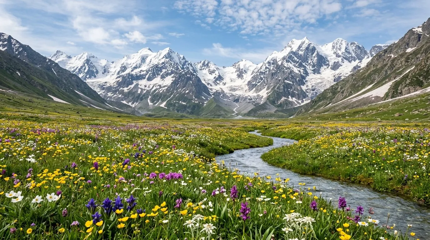
The "Greater Bangus" (Bod Bangus, ~90 sqkm) and "Lesser Bangus" (Lokut Bangus, ~30 sqkm) are post-glacial limestone meadow basins of the western Pir Panjal, sitting between 2,400m and 3,000m. Geomorphologically related to the Gurez basin further east. The dual layout — separated by a low ridge — means the bigger basin gets the festival crowds while Lokut Bangus stays mostly empty even on peak days. Wildflower carpet peaks June-July.
OR INSTEAD · NEIGHBOURING READS
How Bangus Valley stacks against the closest alternatives.
WHAT CROWDS LOOK LIKE
Remote high-altitude valley accessible Jun–Sep when snow melts; winter closure and permit restrictions limit offseason visits.
INFRASTRUCTURE · ON THE GROUND
Srinagar-Bangus 115km ₹5000 (permit + local guide mandatory).
Day trip only. No overnight.
Cash.
None.
None in valley.
Kashmiri + Gujjar.
None.
HOW TO REACH
AIRPORT
Srinagar 130km
RAIL
None
WHERE TO EAT · 3 VERIFIED PICKS
Bangus की ओर जाने वाले Chowkibal मार्ग पर Kupwara शहर का प्रमुख भोजन विकल्प। स्थानीय रूप से संचालित, शहर के भीतर नि:शुल्क होम डिलीवरी।
Tip: Bangus के लिए पैक-अलोंग के रूप में सीख कबाब प्लेट ऑर्डर करें।
Signature: सरल कश्मीरी थाली — राजमा, यखनी, चिपचिपे चावल
Handwara और Bangus घास के मैदान के बीच एकमात्र सत्यापित पका भोजन रसोई। उत्सव के दिनों में बाहरी अतिथियों के लिए खुला और अन्य समय अनुरोध पर। ईमानदार अभाव प्रभावी — उत्सव खिड़की के बाहर, मैदान के लिए पैक्ड भोजन साथ लेकर जाएँ।
Reshwari पहाड़ियों से पहले Handwara पहुँचने पर अंतिम गर्म-भोजन पड़ाव। काम करने वाले वज़वान मेनू पर कश्मीरी रोगन जोश और गुश्ताबा। ट्राउट जब Mawar मछली पकड़ने का मौसम खुला हो (अप्रैल-सितंबर)।
Tip: बहु-व्यंजन पृष्ठ छोड़ें और वज़वान थाली माँगें। ऊपर शुरू करने से पहले थर्मस में कहवा भर लें।
WHERE TO SLEEP · EDITOR'S PICKS
Government tourism tent cluster
हम JKTDC तंबू समूह की ओर इसलिए इशारा करते हैं क्योंकि यह Bangus घास के मैदान के भीतर एकमात्र स्वीकृत रात्रि-विकल्प है — विभाग द्वारा स्थापित 70 दो-व्यक्ति तंबू, +91 9596341934 पर बुकिंग।
“Reshwari से आने-जाने की बजाय घास के मैदान में ही सोना — दिन-भ्रमणकारियों के आने से पहले Bangus की भोर की धुंध देखने का एकमात्र तरीका।”
government_guesthouse
Reshwari में Mawar नदी के किनारे दो गेस्ट लॉज (प्रत्येक में 2 कमरे) — Bangus घास के मैदान में 18 km के ट्रेक से पहले एकमात्र दस्तावेज़ीकृत आधार।
Private cottage homestay
हम इस एकल-कॉटेज संचालन की सिफ़ारिश ट्रेकिंग-प्रधान यात्री के लिए करते हैं। स्थानीय भोजन, अलाव और ट्रेकिंग दर में शामिल — घास के मैदान के निकट JKTDC के बाद एकमात्र निजी विकल्प।
“चालू रसोई, लॉन और अलाव के साथ एकल कॉटेज — 52 साल बंद रहे फ़ायरिंग रेंज के अंदर होमस्टे के सबसे करीब।”
BOOK A STAY · CURATED PROPERTIES
हम बुकिंग से पहले आते हैं, उसके साथ नहीं — नीचे दिए प्लेटफ़ॉर्म पर दाम की तुलना करें।
किसी भी जगह, ठहरने या ऑपरेटर को दिखाने के लिए हम पैसे नहीं लेते। यहाँ दिए किसी लिंक से बुकिंग करने पर हमें थोड़ा कमीशन मिल सकता है, आप पर कोई अतिरिक्त खर्च नहीं। इससे हमारे स्कोर या सुझावों पर कभी असर नहीं पड़ता। संपादकीय नीति
LOCAL LEGENDS · WHO MAKES THIS PLACE
Gujjar shepherd who moonlights as a trekking guide through Bangus Valley. Knows every camping spot, water source, and wildlife corridor. His chai made with goat milk over a wood fire at 3000m altitude is an experience you will not forget.
FESTIVALS · BY THE MONTH
Celebration of the meadow wildflower bloom in the Bangus Valley with camping, folk music, and guided treks through what locals call Mini-Switzerland.
Mawar + Reshwari meadows. Restricted area — permit required.
Packed lunch.
Nomadic Gujjar summer settlement visits.
Return Handwara.
If weather turns
Closed Nov-April.
Tap any traveler type below to see how this place feels for them.
CAUTION — restricted.
Best for
Pristine alpine meadows — LoC restriction kept valley undeveloped; permit-only access
Best for
Summer encampments of Gujjar pastoralists — authentic transhumance witness
Best for
Equivalent meadow grandeur without the tourism infrastructure
Best for
Beyond Handwara — beyond typical tourist circuit
ALSO ON NAKSHIQ
Guides
Everything the guidebook won't tell you — written for India in 2026.
Blog
Long-form reads on regions, festivals, and the offbeat circuit.
Road trips
Driving itineraries with day-by-day stops, distance, and difficulty.
Collections
Wettest places. Sacred lakes. Solo-female-safe. Curated cuts.
NakshIQ 100
India's highest-scoring places, ranked across all 12 months.
The Window
One honest spread, every Sunday. The full back catalogue.
Skip list
Overhyped places with honest alternatives.
First trip
Safety, scams, what to wear, food survival, solo female travel.
FEATURED IN COLLECTIONS
Destinations that come alive in the rains — waterfalls, green valleys, misty mountains, and fewer crowds.
Near-zero light pollution. Milky Way visible to naked eye.
Skip the Instagram spots. These are places most Indians haven't visited — raw, quiet, and unforgettable.
Where BSNL gives up and even God checks voicemail. These destinations force you to look up from your screen.
The edge of the map. Where the road ends and the border begins.
— The NakshIQ editors
TRAVELLERS' VOICE
SHARE YOUR EXPERIENCE
ASK A QUESTION